


Using the high-scale SPH Engineering UgCS mission planning software and a drone with a magnetometer MagArrow suspended 3 meters below it, they were able to access remote areas that were previously difficult to reach.
They used two different methods to study where the minerals are located in a mountainous area. One method involved flying in a helicopter but it was difficult and unsafe to fly at a low altitude. The other method used a small drone that could fly closer to the ground and collect data more easily and accurately. The data collected by the drone showed more detail than the data collected by the helicopter. However, using the drone was still a bit difficult because it had to stay within the pilot's sight at all times. Thus, the research has shown that drone-based magnetometry is a great support to heli-based surveying as it helps to get the most complete information about where the minerals are located in this type of area.

The challenging and complex terrain in the region, particularly around Mount Gonam made exploration difficult. To overcome this, the group of researchers used an aeromagnetic exploration method, which is one of the most commonly used techniques in the mineral exploration field. This method involves using uncrewed aerial vehicles (UAVs) that are convenient, simple to use, and capable of covering large areas quickly, safely, and cost-effectively.
Unmanned Aerial Vehicle (UAV) systems are known for their ease of use and convenience. UAV surveying is a practical and time-efficient method for acquiring data. Thanks to their ability to fly autonomously, UAVs can safely fly close to the ground and gather more detailed information over a wider area.
To obtain a more accurate reading of strong magnetic anomalies, researchers conducted a drone aeromagnetic exploration survey. The drone was equipped with a MagArrow scalar magnetometer. The lightweight MagArrow system, with a sampling rate of 1000 Hz, allowed for data to be acquired every centimeter when flying at 10 m/s. The data was later downsampled to 50 Hz to account for the flight speed and data redundancy.
For this study, the M210RTK drone was chosen for its maximum payload capacity (<1.23 kg) and reliability. During the test flight, no magnetic field interference from the drone was observed in the collected data and no additional calibration was necessary. The maximum flight time with the MagArrow was about 20 minutes. To ensure high-quality data, the flight line spacing and altitude were set at 50 m and 60 m, respectively.
However, using a single drone posed difficulties in maintaining line-of-sight distance due to the rugged, mountainous terrain covered with trees. The flight data was collected 15 times during trips between the take-off and landing points. Collecting data for an area of 25 km2 took a total of approximately 8 hours.
To amplify the subsurface's magnetic anomalies, it was crucial to fly at a low altitude. However, exploring rugged mountainous terrain covered in trees towering over 20 meters can prove difficult and dangerous for low-altitude drone surveying. This type of surveying demands proficient drone operation skills, reliable equipment, and specialized software for mission planning to gather quality data while flying close to the ground.

The study utilized the UgCS software version 4.3.82 by SPH Engineering to plan and conduct surveys in automatic mode. This innovative technology allows for an increase in data capture productivity by at least two times with the automatic photogrammetry planning tool built into the system. With the offline map caching capability, it is possible to plan and fly missions without requiring an internet connection, even in remote desert areas. Additionally, this technology allows you to fly longer routes and resume flights from specific waypoints after changing the battery, making it easier to navigate and collect data even in challenging environments. The drone's altitude was fixed based on the digital elevation model provided by Google (Mountain View, CA, USA). However, as the DEM information can't reflect changes in vegetation, such as tree growth over time, the flight altitude was set at 60 meters for stability. Additionally, to minimize the risk of a flight accident or loss of communication, the survey was carried out by moving the takeoff and landing sites as needed.

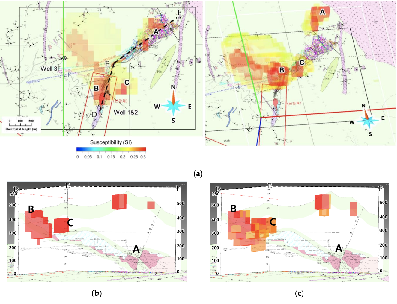
As a result of analyzing the distribution of ore bodies by applying two aeromagnetic methods, low-altitude manned aerial surveys using helicopters were limited due to safety concerns with narrow line spacing. However, using a drone allowed for automatic flight based on sensors, enabling data to be obtained with narrow line spacing and relatively close to the ground. For this reason, the area that appeared to be a single ore body in the inversion result of the aeromagnetic data obtained using a helicopter was clearly distinguished in the inversion result of the aeromagnetic data obtained using the drone.
Therefore, it is recommended that these two methods be used as complements to each other for studying the distribution of ore bodies in complex mountainous terrain covered with trees.