


- A site manager must plan excavation work and understand earth balance, i.e. cut and fill activities.
- Differences in landscapes for two consecutive dates may show a field engineer the current work speed and ability to meet the plan.
- In the mining industry, a storage area manager needs to know the amount of material and the utilization of different storage zones.
All these tasks have a lot in common. They all require a comparison of digital elevation models (DEM). Typically, you have two DEMs: one is the reference surface and the other is the current surface. The reference surface can be a landscape from some previous moment in time or a 3D design from CAD/BIM software with desired geometry.
There are two types of landscape models:
- Digital Surface Model (DSM) which represents elevation levels of the highest visible points, like rooftops, trees, cars, and the ground
- Digital Terrain Model (DTM) which represents ground level without trees, cars, buildings, etc.

Given that said we can build simple equations for different problems:
How to get DSM and DTM
DSM can be a result of photogrammetry or LIDAR survey. Most popular approach is to fly a drone with a photo camera or a LIDAR using the regular pattern, similar to the picture below

More information about the specifics of flight planning can be found in these two articles:
Depending on the sensor type, DSM can be generated using the following techniques:
If you have only DSM, there is a way how you can make a reference DTM surface for further comparison operations.
In ATLAS there is a tool which allows users to draw perimeter and interpolate elevation inside it using altitudes on perimeter vertices.

ATLAS is a cloud based GIS for drone users. It allows to store, visualize, measure, compare, annotate and share spatial data, such as: orthomosaics, DEM, point cloud, 2D/3D design.
Volume measurement
ATLAS has a rich set of tools for volume measurements. Essentially, volume measurement always consists of the following steps:
- Draw a polygonal area of interest on the map.
- Select the current DSM.
- Select the reference level/surface.
- Calculate the volume as four values: cut, fill, net, total.
ATLAS supports four types of reference surfaces:

There are 4 values characterizing volume measurement:
- CUT - amount of “earth” required to be removed to reach the reference surface level
- FILL - amount of “earth” required to be brought to the site to reach the reference surface level
- NET - shows “earth” balance for the site. Calculated as FILL - CUT
- TOTAL - shows total amount of “earth” to be moved, both removed and brought. Calculated as FILL + CUT
It is very important to visualize the difference between the current landscape(DSM) and a reference surface. To do that ATLAS allows to specify ranges of elevation differences and respective colors.
Several examples of heatmaps

Changes in DSM of the construction site for 2 different dates

Comparison of current DSM against possible flood level (absolute AMSL)

Comparison of DSM against 3D design
Reporting
Most of the clients need a report in PDF format which contains information about the site in general and more details for specific areas of interest. Report can be exported directly from the Measurements context menu. All selected(visible on the map) volumes are included.
Report consists of several sections.
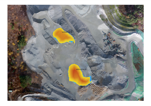
Spreadsheet with all selected areas of interest and their Cut&Fill values

Each area of interest has a dedicated page with a screenshot, Cut&Fill values and legend with zones of differences in elevation. Each zone has a color and the area size covered. Area size can be used, for example, to analyze the utilization of stockpile storage areas. By properly configuring elevation difference ranges we can split areas into zones which should be considered as free and occupied. For example all differences of elevation between DSM and DTM less than 1.5 meters can be considered as free. All zones with a greater difference can be considered as occupied.

Conclusion
Landscape change detection and volume measurement is a crucial part of the construction and mining earthwork management process. If you need help in setting up a workflow for your GIS or drone department, contact us!